tebetebe: routing analysis with OSM
tebetebe is a Python API to compile, serve, and query routable networks using the Open Source Routing Machine (OSRM) and OpenStreetMap data, and provides a framework for routing analysis using these networks.
Package Overview
tebetebe makes it easy to compile a custom routing Scenario by abstracting OSRM executables into a pythonic API and provides a framework for routing analysis. With the range of customization available in the .lua configuration scripts, specific, accurate and readable transportation models can be developed and analyzed.
tebetebe also simplifies the routing analysis pipeline by enabling data to be pulled live from the OSM via the Overpass API and providing various user-contributed classes which automate common routing analysis tasks, such as isochrones.
Installation
1. Install osrm-backend binaries
See the osrm-backend wiki for instructions on how to build and install from source.
Note that the osrm-backend Docker images are not supported for use with tebetebe.
2. (option 1) Install from pip
pip3 install tebetebe
Examples
Simple Scenario
This example uses the eSwatini GeoFabrik extract and the default walking profile to calculate a walking route between Simunye and Mbabane.
from tebetebe.profiles import foot
import tebetebe as tb

tb_env = tb.Environment(tmp_dir="./tmp/simple_scenario")

mbabane = (31.1367, -26.3054)
simunye = (31.9274, -26.2108)

## Initialize scenario using eSwatini GeoFabrik extract and default foot profile
scenario = tb_env.Scenario("./tmp/swaziland-latest.osm.pbf", foot)

## Compile and run scenario
with scenario() as api:
    ## Query OSRM HTTP `simple_route` service to calculate route
    route = api.simple_route(simunye, mbabane)

    duration = route['routes'][0]['duration'] / 60
    distance = route['routes'][0]['distance'] / 1000

    print("Walking from Simunye to Mbabane")
    print(" Duration: {:.2f} minutes".format(duration))
    print(" Distance: {:.2f} km".format(distance))
 [   INFO] swaziland-latest_foot: Compiling scenario (MLD)
 [WARNING] swaziland-latest_foot: Default foot profile may not be accurate for your use case
 [   INFO] swaziland-latest_foot: Initializing scenario
 [   INFO] swaziland-latest_foot: Ready for requests
 Walking from Simunye to Mbabane
  Duration: 1420.70 minutes
  Distance: 118.39 km
Scenario Comparison
By comparing origin:destination routes between different scenarios, we gain insight about how changing a transportation scenario affects route patterns.
Here, we compare routes calculated by two different Scenarios: a “normal” walking scenario, and a “flood” scenario, to understand the impact of a flooding event on access to local schools in eSwatini. The route network is taken from the eSwatini GeoFabrik extract, and the homesteads (origins) and schools (destinations) are downloaded from the Overpass API.
The “normal” and “flood” scenarios in this case are both the default walk profile, except that the “flood” scenaro considers nodes with ford=yes (river crossings), and ways with flood_prone=yes to be a barrier. Check out their source in the GitHub repo
from tebetebe.analysis import ParallelScenarios, RouteComparison
import tebetebe as tb

tb_env = tb.Environment(tmp_dir="./tmp/scenario_comparison")

## Get route network from GeoFabrik extract and POIs from Overpass API
## Load the route origins (homesteads) and dests (schools) 8km around river crossing
crossing_node_id = 6750683291
highways = tb_env.OSMDataset("./tmp/swaziland-latest.osm.pbf", name="swazi")
homesteads = tb_env.POIDataset.from_overpass("""node({})->.crossing;
                                                 ( way(around.crossing:8000)["building"];);
                                                out center;""".format(crossing_node_id),
                                             name="homesteads")
schools = tb_env.POIDataset.from_overpass("""node({})->.crossing;
                                                 ( way(around.crossing:8000)["amenity"="school"];);
                                                out center;""".format(crossing_node_id),
                                          name="schools")

## Normal & Flood scenarios. Pass along an extra parameter to osrm-routed
## so that the max duration table size is enough for all origin:dest pairs
routed_args = {"max_table_size": len(homesteads) * len(schools) + 1}

normal = tb_env.Scenario(highways, "./profiles/walk_normal.lua",
                         routed_args=routed_args, name="normal")
flood = tb_env.Scenario(highways, "./profiles/walk_flood.lua",
                        routed_args=routed_args, name="flood")

## Run normal and flood scenarios in parallel
parallel_scenarios = ParallelScenarios(normal, flood)

with parallel_scenarios as scenarios:
    ## Compare origin:dest routes
    comparison = RouteComparison(origins=homesteads, dests=schools)

    ## Routes that are different between scenarios
    flood_affected = comparison.get_difference(normal, flood)

    ## Point dataframe of all homesteads who are flood affected
    homesteads[homesteads.index.isin(flood_affected['origin_id'].unique())] \
        .to_file(tb_env.tmp_dir / "flood_affected_homesteads.geojson", driver="GeoJSON")

    ## Routes of all flood affected homesteads under normal conditions
    comparison.get_routes(normal, od_pairs=flood_affected) \
        .to_file(tb_env.tmp_dir / "flood_affected_normal_routes.geojson", driver="GeoJSON")

    ## Routes of all flood affected homesteads under flood conditions
    comparison.get_routes(flood, od_pairs=flood_affected) \
        .to_file(tb_env.tmp_dir / "flood_affected_flood_routes.geojson", driver="GeoJSON")
 [   INFO] Downloading POIDataset homesteads
 [   INFO] Downloading POIDataset schools
 [   INFO] normal: Compiling scenario (MLD)
 [   INFO] normal: Initializing scenario
 [   INFO] normal: Ready for requests
 [   INFO] flood: Compiling scenario (MLD)
 [   INFO] flood: Initializing scenario
 [   INFO] flood: Ready for requests
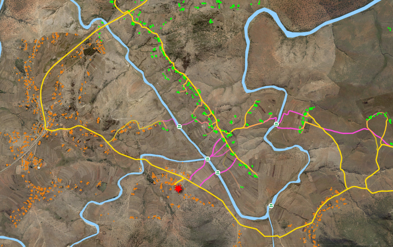
Scenario Comparison results visualized in QGIS. Flood Affected homesteads (Green), Normal Routes (Pink), Flood Routes (Yellow)
Access Isochrones
Here a route network is extracted from the eSwatini GeoFabrik extract and an AccessIsochrone is calculated using the default car profile. The AccessIsochrone class is provided by the python-osrm package.
from tebetebe.analysis import AccessIsochrone
from tebetebe.profiles import car
import tebetebe as tb

tb_env = tb.Environment(tmp_dir="./tmp/access_isochrones")
mbabane = (31.1367, -26.3054)

## Initialize scenario with GeoFabrik extract and default car profile
scenario = tb_env.Scenario("./tmp/swaziland-latest.osm.pbf", car)

## Compile and run scenario
with scenario() as api:
    isochrone = AccessIsochrone(api, mbabane, points_grid=1000, size=0.2)
    contours = isochrone.render_contour(10)

    ## Save contours as GeoJSON for visualization with QGIS
    contours.to_file(tb_env.tmp_dir / "contour10.geojson", driver="GeoJSON")
 [   INFO] swaziland-latest_car: Compiling scenario (MLD)
 [WARNING] swaziland-latest_car: Default car profile may not be accurate for your use case
 [   INFO] swaziland-latest_car: Initializing scenario
 [   INFO] swaziland-latest_car: Ready for requests
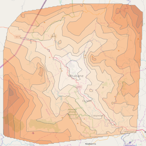
Result visualized over OSM Carto basemap
API Documentation
tb.Scenario
-
class
tebetebe.Scenario.Scenario(osm_dataset, routing_profile, name=None, algorithm='MLD', tmp_dir=PosixPath('/tmp'), overwrite=False, verbose=False, **kwargs)[source]¶ Bases:
objectScenario is an abstraction of OSRM executables in order to compile, serve, and query a routable network.
A Scenario is initialized with (1) an OSM Dataset and (2) a Routing Profile. When called, Scenario compiles the OSMDataset and RoutingProfile into an OSRM routable network, provides a context manager to serve the scenario’s HTTP API, and returns various methods to query that API.
The HTTP API methods (match, nearest, simple_route, table, trip) are provided by the python-osrm module (https://github.com/ustroetz/python-osrm)
Example
>>> from tebetebe.profiles import foot
>>> import tebetebe as tb
>>>
>>> ## initialize scenario with GeoFabrik extract & default foot profile
>>> scenario = tb.Scenario("./swaziland-latest.osm.pbf", foot)
>>>
>>> with scenario() as api: ## compile scenario and serve HTTP API
>>>     api.simple_route()... ## query HTTP API for a simple route, match, nearest, trip...
- Parameters
osm_dataset (str / OSMDataset) – OSM dataset from which the route network will be extracted
routing_profile (str / RoutingProfile) – Routing profile to be used in scenario
name (str, optional) – Scenario name used in output file and log entries. If not supplied, it will be built based upon the OSMDataset and RoutingProfile names
algorithm (str, optional) – Algorithm to be used (either “CH” or “MLD”)
tmp_dir (str, optional) – Temporary directory to store files generated by osrm binaries
overwrite (bool, optional) – Overwrite scenario if .osrm* files already exist. Otherwise, the existing .osrm* files will be used.
verbose (bool, optional) – Print output of OSRM compilation
**kwargs – To pass any custom arguments to the OSRM executables (“osrm-routed”, “osrm-contract”, …) pass the kwarg “{executable}_args” (ex. “routed_args”, “contract_args”, …) with a dictionary of key:values to be passed
-
match(steps=False, overview='simplified', geometry='polyline', timestamps=None, radius=None, annotations='false', gaps='split', tidy=False, waypoints=None, url_config=http://localhost:5000/*/v1/driving)¶ Function wrapping OSRM ‘match’ function, returning the reponse in JSON
- Parameters
points (list of tuple/list of point) – A sequence of points as (x ,y) where x is longitude and y is latitude.
steps (bool, optional) – Default is False.
overview (str, optional) – Query for the geometry overview, either “simplified”, “full” or “false” (Default: “simplified”)
geometry (str, optional) – Format in which decode the geometry, either “polyline” (ie. not decoded), “geojson”, “WKT” or “WKB” (default: “polyline”).
timestamps (list of timestamp, optional) –
radius (list of float, optional) –
annotations (bool, optional) –
gaps (str, optional) –
tidy (bool, optional) –
waypoints (list of tuple/list of point, optional) –
url_config (osrm.RequestConfig, optional) – Parameters regarding the host, version and profile to use
- Returns
The response from the osrm instance, parsed as a dict
- Return type
dict
-
nearest(number=1, url_config=http://localhost:5000/*/v1/driving)¶ Useless function wrapping OSRM ‘nearest’ function, returning the reponse in JSON
- Parameters
coord (list/tuple of two floats) – (x ,y) where x is longitude and y is latitude
number (int, optional) –
url_config (osrm.RequestConfig, optional) – Parameters regarding the host, version and profile to use
- Returns
result – The response from the osrm instance, parsed as a dict
- Return type
dict
-
simple_route(coord_dest, coord_intermediate=None, alternatives=False, steps=False, output='full', geometry='polyline', overview='simplified', annotations='true', continue_straight='default', url_config=http://localhost:5000/*/v1/driving, send_as_polyline=True)¶ Function wrapping OSRM ‘viaroute’ function and returning the JSON reponse with the route_geometry decoded (in WKT or WKB) if needed.
- Parameters
coord_origin (list/tuple of two floats) – (x ,y) where x is longitude and y is latitude
coord_dest (list/tuple of two floats) – (x ,y) where x is longitude and y is latitude
coord_intermediate (list of 2-floats list/tuple) – [(x ,y), (x, y), …] where x is longitude and y is latitude
alternatives (bool, optional) – Query (and resolve geometry if asked) for alternatives routes (default: False)
output (str, optional) – Define the type of output (full response or only route(s)), default : “full”.
geometry (str, optional) – Format in which decode the geometry, either “polyline” (ie. not decoded), “geojson”, “WKT” or “WKB” (default: “polyline”).
annotations (str, optional) –
continue_straight (str, optional) –
overview (str, optional) – Query for the geometry overview, either “simplified”, “full” or “false” (Default: “simplified”)
url_config (osrm.RequestConfig, optional) – Parameters regarding the host, version and profile to use
- Returns
result – The result, parsed as a dict, with the geometry decoded in the format defined in geometry.
- Return type
dict
-
table(coords_dest=None, ids_origin=None, ids_dest=None, output='np', minutes=False, annotations='duration', url_config=http://localhost:5000/*/v1/driving, send_as_polyline=True)¶ Function wrapping OSRM ‘table’ function in order to get a matrix of time distance as a numpy array or as a DataFrame
- Parameters
coords_src (list) –
- A list of coord as (longitude, latitude) , like :
- list_coords = [(21.3224, 45.2358),
(21.3856, 42.0094), (20.9574, 41.5286)] (coords have to be float)
coords_dest (list, optional) –
- A list of coord as (longitude, latitude) , like :
- list_coords = [(21.3224, 45.2358),
(21.3856, 42.0094), (20.9574, 41.5286)] (coords have to be float)
ids_origin (list, optional) – A list of name/id to use to label the source axis of the result DataFrame (default: None).
ids_dest (list, optional) – A list of name/id to use to label the destination axis of the result DataFrame (default: None).
output (str, optional) –
- The type of annotated matrice to return (DataFrame or numpy array)
’raw’ for the (parsed) json response from OSRM ‘pandas’, ‘df’ or ‘DataFrame’ for a DataFrame ‘numpy’, ‘array’ or ‘np’ for a numpy array (default is “np”)
annotations (str, optional) – Either ‘duration’ (default) or ‘distance’
url_config (osrm.RequestConfig, optional) – Parameters regarding the host, version and profile to use
- Returns
- if output==’raw’ (a dict, the parsed json response.)
- if output==’np’ (a numpy.ndarray containing the time in minutes,) – a list of snapped origin coordinates, a list of snapped destination coordinates.
- if output==’pandas’ (a labeled DataFrame containing the time matrix in minutes,) – a list of snapped origin coordinates, a list of snapped destination coordinates.
-
trip(steps=False, output='full', geometry='polyline', overview='simplified', roundtrip=True, source='any', destination='any', annotations='false', url_config=http://localhost:5000/*/v1/driving, send_as_polyline=True)¶ Function wrapping OSRM ‘trip’ function and returning the JSON reponse with the route_geometry decoded (in WKT or WKB) if needed.
- Parameters
coord_origin (list/tuple of two floats) – (x ,y) where x is longitude and y is latitude
steps (bool, default False) –
output (str, default 'full') – Define the type of output (full response or only route(s))
geometry (str, optional) – Format in which decode the geometry, either “polyline” (ie. not decoded), “geojson”, “WKT” or “WKB” (default: “polyline”).
overview (str, optional) – Query for the geometry overview, either “simplified”, “full” or “false” (Default: “simplified”)
roundtrip (bool, optional) –
source (str, optional) –
destination (str, optional) –
annotations (str, optional) –
url_config (osrm.RequestConfig, optional) – Parameters regarding the host, version and profile to use
- Returns
- if ‘only_index’ (a dict containing respective indexes) – of trips and waypoints
- if ‘raw’ (the original json returned by OSRM)
- if ‘WKT’ (the json returned by OSRM with the ‘route_geometry’ converted) – in WKT format
- if ‘WKB’ (the json returned by OSRM with the ‘route_geometry’ converted) – in WKB format
tb.OSMDataset
-
class
tebetebe.OSMDataset.OSMDataset(osm_path, name=None, **kwargs)[source]¶ Bases:
objectOSM data file from which a route network will be extracted
- Parameters
osm_path – Path to *.osm{.pbf} dataset
name (str, optional) – Name of OSMDataset. If not provided, the .osm filename is used.
-
classmethod
from_overpass(query, name=None, overwrite=False, tmp_dir=PosixPath('/tmp'), **kwargs)[source]¶ Initialize an OSMDataset by downloading result of an overpass query and saving as .osm
- Parameters
query (str) – Query to be sent to overpass API. This query should not include an out directive (eg. [out:xml];)
name (str) – Name of the route network
overwrite (bool) – Overwrite route network if it already exists on disk
tmp_dir (str) – Temporary directory to save route network
- Returns
- Return type
tb.RoutingProfile
-
class
tebetebe.RoutingProfile.RoutingProfile(lua_path, name=None, default=False, **kwargs)[source]¶ Bases:
objectA RoutingProfile is a configuration script which represents a routing behaviour, such as for bike or car routing. It describes whether or not to traverse a particular type of way or node in OSM data, and the speed at which those elements are traversed.
Check out the osrm-backend wiki for more information! https://github.com/Project-OSRM/osrm-backend/wiki/Profiles
- Parameters
lua_path (str) – Path to .lua configuration script
name (str, optional) – Name of routing profile. If not provided, the .lua filename is used.
default (bool, optional) – If RoutingProfile is a default profile
tb.POIDataset
-
class
tebetebe.POIDataset.POIDataset(*args, name=None, **kwargs)[source]¶ Bases:
geopandas.geodataframe.GeoDataFrameExtension of a GeoDataFrame which stores Points only, to be used as origin, destination, and waypoints in routing.
- Parameters
name (str) – Name of POIDataset (required)
-
classmethod
from_features(features, name=None, **kwargs)[source]¶ Initialize POIDataset from GeoJSON features
-
classmethod
from_file(path, name=None, **kwargs)[source]¶ Initialize POIDataset from file. If no name is given, the filename will be used
-
classmethod
from_overpass(query, name=None, overwrite=False, tmp_dir=PosixPath('/tmp'), **kwargs)[source]¶ Initialize POIDataset from Overpass API query. Any returned nodes or closed ways with center attributes will be included in the dataset.
- Parameters
query (str) – Query to be sent to overpass API. This query should not include an out directive (eg. [out:json];)
name (str) – Name of the POI dataset
overwrite (bool) – Overwrite POIDataset if it already exists on disk
tmp_dir (str) – Temporary directory to save POIDataset
tb.Environment
-
class
tebetebe.Environment.Environment(**kwargs)[source]¶ Bases:
objectEnvironment is a convenience class to set default options for the tebetebe base classes.
Many of the tebetebe operations require writing a file to disk in order to be passed to the OSRM executables, and it’s useful to set a uniform tmp_dir for a particular set of commands so that all of these files generated by those commands are contained in the same place.
In addition to tmp_dir, any **kwarg passed to Environment will be passed to all of the classes available under the Environment. Useful examples of these kwargs include verbose and overwrite
Any **kwargs set in Environment classes will be overridden if the argument is specified during subclass initialization.
- Parameters
**kwargs – Arbitrary keyword arguments to be passed to each class available under the Environment
tb.OSRM
-
class
tebetebe.OSRM.OSRM(verbose=False)[source]¶ Bases:
objectBase class wrapper around all the osrm-* binaries. All functions accept additional **kwargs to be passed upon execution. This class is used in the background and need not be initialized directly.
- Parameters
verbose (bool) – Output stdout from osrm commands.
-
extract(osm_path, profile_path, **kwargs)[source]¶ Call osrm-extract with a path to the osm route network and lua profile.
-
routed(osrm_file, ready_callback, done_callback, verbose=False, **kwargs)[source]¶ Call osrm-routed on a .osrm file
- Parameters
osrm_file (str) – Path to *.osrm
ready_callback (function) – Function to be called when osrm-routed is ready for HTTP requests
done_callback (function) – Function to be called when osrm-routed has exited
verbose (bool) – osrm-routed output is so verbose it is default off even if the parent class verbose=True. Set this to true if you want to see osrm-routed output anyway.
**kwargs – Any additional parameters to be passed to osrm-routed
Analysis Plugins
Analysis plugins are classes written on top of the tebetebe base classes to automate routing analysis
tb.analysis.AccessIsochrone
-
class
tebetebe.analysis.AccessIsochrone.AccessIsochrone(scenario, point_origin, points_grid=500, size=0.4)[source]¶ Bases:
osrm.extra.AccessIsochroneCompute an access isochrone from an origin point with a given ScenarioAPI
- Parameters
scenario (Scenario) – Scenario to be queried for access isochrone
point_origin (2-floats tuple) – The coordinates of the center point to use as (x, y).
points_grid (int) – The number of points of the underlying grid to use.
size (float) – Search radius (in wgs84 degrees)
tb.analysis.ParallelScenarios
-
class
tebetebe.analysis.ParallelScenarios.ParallelScenarios(*args)[source]¶ Bases:
objectContext manager for serving multiple scenarios in parallel. This can be useful for comparing routing analysis from multiple scenarios side by side.
- Parameters
*args – Arbitrary number of scenarios to be compiled, then executed in parallel
tb.analysis.RouteComparison
-
class
tebetebe.analysis.RouteComparison.RouteComparison(origins, dests, origins_id_col=None, dests_id_col=None, cache=True)[source]¶ Bases:
objectCompare route differences between scenarios
- Parameters
origins (POIDataset) – Points to be used as the origins in route comparison
dests (POIDataset) – Points to be used as the destinations in route comparison
origins_id_col (str, optional) – Column in origins dataset to be used as ID. Must be unique. If not specified, the index will be used
dests_id_col (str, optional) – Column in dests dataset to be used as ID. Must be unique. If not specified, the index will be used
cache (bool, optional) – Whether to cache time matrices
-
get_difference(scenario0, scenario1)[source]¶ Get DF of origin:dest pairs whos routes differ between scenarios
-
get_duration_matrix(scenario, melted=False)[source]¶ Calculate a duration matrix between origins and dests
- Parameters
scenario (Scenario) – Scenario to run calculate the duration matrix on
melted (bool, optional) – Whether the matrix should be returned as a matrix DF, or melted into origin_id dest_id and duration columns
- Returns
Duration Matrix DataFrame
- Return type
pd.DataFrame
-
get_duration_table(*args)[source]¶ Get route duration table for multiple scenarios
- Parameters
*args – Arbitrary number of scenarios to run duration table
- Returns
DF of origin:dest pairs and durations for each scenario
- Return type
DataFrame
-
get_routes(scenario, od_pairs=None)[source]¶ Get routes between origins and dests
- Parameters
scenario (Scenario) – Scenario on which the origin:dest routes will be calculated
od_pairs (pd.DataFrame, optional) – DataFrame of origin:dest pairs in two columns origin_id and dest_id for calculation. If not specified, all pairwise origin:dest routes will be calculated.
- Returns
GDF with duration, distance, and route geometry for each origin:dest pair
- Return type
GeoDataFrame